With careful land grading and precise excavation, you create a stable base that directs water away, reduces soil shifting, and supports structures for decades; by prioritizing proper drainage, compaction, and correct slope you avoid water damage and foundation failure, while achieving a durable, long-lasting foundation that saves time and cost—learn more from Excavate Alaska: https://excavatealaska.com/
You must know how precise excavation and proper land grading combine to create a stable base for your structure. Excavation removes unsuitable soil, while grading sculpts slopes to direct water away and prevent erosion. Poor drainage or inadequate compaction can cause costly, dangerous foundation failure. By coordinating both, you get improved load-bearing capacity, longer service life, and lower repair risk. For professional guidance tailored to Alaska conditions, visit https://excavatealaska.com/.
Key Takeaways:
- Thorough excavation creates the correct subgrade and footing depths by removing unsuitable soils and exposing stable material—especially important in Alaska, where frost depth and permafrost affect foundation performance.
- Proper land grading directs surface water away from the foundation, reducing hydrostatic pressure, erosion, and risk of frost heave; planned slopes, swales, and drainage features protect long‑term stability.
- Coordinated planning and execution of excavation, compaction, backfill, and erosion control—along with testing and code compliance—prevent costly rework and extend the life of the foundation.
For more on professional grading and excavation services, visit https://excavatealaska.com/
The Critical Role of Land Grading in Foundation Stability
Defining Land Grading: The Basics
Grading shapes the surface contours so water runs away from your foundation, typically with a minimum 2% slope for the first 10 feet, and removes organic topsoil that can decay and settle. You want engineered fill and stable subgrade materials placed and compacted to design specs; otherwise, hydrostatic pressure, erosion, and differential settlement can develop and damage footings. Good grading ties directly to excavation depth and footing design, so coordinate soil removal and final elevations before you pour concrete.
Techniques and Machinery Used in Grading
Motor graders, bulldozers (D4–D8 class), track and wheeled excavators, and skid steers with box blades handle gross cut-and-fill while vibratory rollers and sheepsfoot compactors deliver required compaction—commonly specified at 95% of standard Proctor. Laser or GPS grade-control systems reduce rework and keep slopes within tight tolerances. Trenching/bedrock cutting often calls for hydraulic hammers or blasting, depending on site conditions.
For a typical residential site, you might move several hundred to a few thousand cubic yards of material; planning machine productivity helps you estimate schedule. Motor graders with 12–14 ft blades often finish-grade faster than dozers on larger spreads, while a D6 dozer paired with a 10-ton roller can achieve target compaction rates efficiently. In wet or freeze-prone areas, you’ll stage lifts of engineered fill at controlled moisture contents and compact each lift (commonly 6–12 inches thick) to meet density specs. GPS-guided grading cuts manual staking time and errors, and using geotextile separation fabrics or a crushed-rock cap can mitigate frost heave in Alaska soils. Coordinate your grading plan with excavation team members so elevations, cut depths, and drainage swales match the foundation layout and local code requirements.
The Interplay of Grading and Excavation
Defining Land Grading and Excavation
Land grading adjusts surface elevations to direct water and create buildable pads, typically establishing a minimum 2% slope away from foundations. At the same time, excavation removes unsuitable soils—organic peat, soft silts—and exposes competent material for footings. You’ll often strip the top 6–24 inches of organics and dig footings to depths of 3–6+ feet in colder Alaskan zones to get below the frost line and frost-susceptible layers.
Core Principles of Their Collaboration
Sequencing, soil testing, and compaction tie grading and excavation together: you strip and test soils, cut or fill to design grades, then place engineered fill in lifts, compacted to common targets like 95% standard or modified Proctor. Proper benching and shoring during cuts, plus temporary dewatering, reduce collapse risk and protect crews and equipment.
Onsite coordination saves time and money by designing plans that minimize haul distances through balanced cut and fill, reduce truck counts, and lower fuel use. You should place fill in 6–8 inch lifts, control moisture to within ±2% of optimum, and use vibratory rollers for granular layers. Geotextile separation between native peat and granular fill, subdrains behind retaining features, and daylighted swales prevent long-term saturation that leads to frost heave or slope failure. In permafrost-prone areas, you may specify removal of the upper organic layer and replacement with well-graded crushed rock, or adopt frost-protected shallow foundation details—both decisions driven by geotechnical borings and a clear plan that sequences grading immediately after excavation to limit exposure of cut slopes to freeze–thaw cycles.
The Importance of Site Assessment in Grading and Excavation
Evaluating Soil Composition and Stability
You need targeted boreholes, SPT or CPT data, and lab tests (Atterberg limits, gradation) to classify soils; organic layers, loose silts, or peat can have bearing capacities under 500–1,500 psf, while compacted gravel often sustains 2,000–4,000 psf. Calibrate excavation depths to expose competent material or plan structural fill and compaction specifications; in Alaska, account for variable frost depths and potential thaw settlement when establishing footing elevations.
Identifying Natural Drainage Patterns
You should map contours, existing swales, and seasonal runoff to locate where water concentrates; even small basins can produce concentrated flow during spring thaw, so design grading to achieve a minimum 2% slope away from foundations and avoid low points within 10 feet of the structure. Mark legacy features—old gravel pits, culverts, springs—that redirect flow.
Use a topographic survey or LiDAR plus spot checks with a transit or laser level to trace overland flowlines and calculate catchment areas for each runoff path; that allows you to size swales, culverts, and underdrains to handle spring melt and storm events (design to at least a 10-year event on residential sites). Locate proposed storm outlets at natural low points or extend outfall pipes to stable dispersal areas, and plan temporary dewatering (pumps commonly in the 50–200 gpm range for small sites) during excavation if groundwater or seasonal thaw threatens the subgrade. Incorporate erosion controls—silt fence, riprap, or lined channels—where concentrated flow could undermine the cut slopes or carry sediment onto neighboring properties.
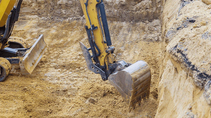
Excavation: The Backbone of a Secure Build
Excavation Processes: From Planning to Execution
Start with geotechnical borings and test pits to determine bearing capacity, groundwater depth, and any organics that need to be removed. Typically, at least one boring is required per 500–1,000 sq ft or major footing line on complex sites. You’ll sequence work by clearing topsoil, protecting utilities, then cutting to the designed subgrade elevations—footings often end up 3–5 feet below finished grade or to the frost-susceptible layer. Controlled benching, dewatering, and verification testing keep the schedule and spec compliance tight.
Essential Equipment for Effective Excavation’ll rely on hydraulic excavators (2–50 ton classes), skid steers, dozers, and haul trucks for bulk cuts, plus compactors, laser-grade systems, and trench boxes/shoring for safety; pumps and rock breakers are standard in Alaska for groundwater and frozen or bedrock conditions. Right-sizing machines to soil and access minimizes rework and keeps costs down.
Choose an excavator class to match volume: a 20-ton machine typically handles most residential foundations, while 30–50 ton units move heavy loads on commercial jobs. Use plate compactors (rammers for trenches, vibratory rollers for larger pads) to meet compaction targets—often >95% of Proctor density (ASTM D698) under footings. For frozen or rocky ground, plan on hydraulic hammers or hydraulic rock saws; add a licensed trenching crew and shoring systems to prevent cave-ins, and employ laser or GPS grade control to hold elevations within +/- 0.02–0.05 ft for slab-on-grade tolerances.
The Importance of Proper Site Preparation
Assessing Soil Type and Stability
You should have a geotechnical assessment that classifies soils—sandy gravels (~3,000–6,000 psf), silty clays (~1,000–3,000 psf), and organic peat (<500 psf)- that behave very differently under load. In Alaska, thawing permafrost and peat layers are the most dangerous, producing large settlements and loss of bearing capacity; probing, borings, and simple plate-load tests help you map these hazards before you grade or excavate.
Impact on Load Distribution and Foundation Strength
Proper grading and excavation create a uniform subgrade so loads spread evenly across footings; engineers often design for specific bearing capacities and specify compaction to 95% Standard Proctor (98% under footings) to limit settlement. If you leave organic soils in place or fail to compact engineered fill, you risk excessive differential settlement that can crack slabs, shift walls, and void warranties.
Digging to competent material and controlling the backfill process changes how loads travel: shallow spread footings on compacted gravel can safely carry 2,000–4,000 psf, but where you encounter peat or seasonally thawing frost, you may switch to deep foundations—driven piles or helical anchors—to transfer loads below the problem layer. In practice, you might undercut 12–36 inches of unsuitable soil and replace it with crushed rock compacted to >95% to achieve a target bearing capacity (for example, upgrade a peat site from <500 psf to ~3,000 psf), or specify piles to bypass 6–10 feet of soft material. Geotextiles, stone columns, and controlled grading slopes also limit lateral movement and reduce differential settlement; aiming for under 1 inch of differential settlement across a foundation is a common performance threshold to avoid structural damage and finish cracks.
Crafting the Perfect Grading Plan: Key Factors
- Site topography — contour lines, existing slopes, and natural drainage paths determine how much cut or fill you need.
- Subsurface soil type and bearing capacity — clay, silt, sand, or permafrost each changes compaction strategy and footing depth.
- Drainage and stormwater management — roof and surface runoff must follow planned swales, culverts, or engineered drains.
- Frost depth and seasonal freeze/thaw — specify frost protection measures where depth exceeds 48 inches in northern zones.
- Existing utilities and structures — locate services, slope buffers, and potential conflict zones before heavy excavation.
- Slope stability and erosion control — slopes over 15% often need terracing, geogrid, or retaining walls to prevent slide risk.
- Permitting and local code requirements — setbacks, compaction standards, and inspection checkpoints drive sequencing and schedule.
Topography and Landscape Features
Local contours dictate how much cut or fill you plan: a 2% minimum grade away from foundations prevents pooling, while natural low spots may require engineered swales or small retention basins. Expect to design retaining walls for slopes exceeding 15%, and use existing tree lines as natural erosion buffers where possible to reduce imported fill volume.
Understanding Local Building Codes and Regulations
Permit packages often demand geotechnical reports, erosion control plans, and specific compaction targets like 95% Standard Proctor. You should budget for permit review times of roughly 2–8 weeks and anticipate inspection stages at footing, backfill, and final grade to verify compliance.
Many jurisdictions adopt the International Building Code with local amendments; in Alaska, that can mean stricter requirements for frost protection, anchoring of retaining structures, and higher minimum setbacks in floodplains. You will frequently need a soils report when proposed fills exceed 2 feet or slopes are steeper than 5%, and engineered drainage details if your site discharges to municipal systems. Failure to meet compaction or frost-protection mandates often leads to settlement, utility failure, or frost heave—issues that drive costly remediation and extended inspections. Recognizing local requirements early in your grading plan prevents permit delays, expensive rework, and long-term structural problems.
The Interplay Between Land Grading and Excavation
Synchronization of Techniques for Optimal Results
Plan sequencing so grading and excavation act as one workflow: you rough-cut to subgrade, place engineered fill in 150–300 mm lifts, and compact to 95% Standard Proctor before formwork. Maintain a 2% grade (≈1/”” per foot) away from the foundation for the first 10 feet, bench slopes into undisturbed soil on cuts over 3:1, and stage spoil to avoid recontamination. Proper machine staging—excavator, dozer, and roller—reduces rework and saves time and cost while protecting bearing capacity and drainage paths.
Case Scenarios: When One Fails, the Other Suffers
Poor grading can funnel surface water against foundations, causing hydrostatic pressure and basement leaks even if excavation followed specs; conversely, over-excavation or inadequate compaction can create excessive settlement and slope instability despite correct topsoil grading. Typical failures you’ll see include saturated backfill losing strength or a 25–50 mm settlement crack after insufficiently compacted lifts under a slab.
For example, on a residential build in Interior Alaska where frost depth is often 3–5 ft (0.9–1.5 m), failing to reestablish the 2% runoff grade after trenching led to ice lensing and heave that shifted footings 40 mm. In another case, a developer removed bearing silt without benching and replaced it with uncompacted fill; you would notice immediate differential settlement and stair-step cracks within months. These scenarios underscore that grading and excavation specifications—lift thickness, compaction percent, frost considerations, and drainage grading—must be checked together, not in isolation.
The Grading Process: More Than Just Leveling
Techniques for Effective Grading
Rough grading establishes the site’s macro contours with bulldozers and motor graders. In contrast, finish grading relies on skid steers, laser-guided box blades, or GPS-controlled graders to hit tolerances of ±0.1 ft. You should place fills in 6–12 inch lifts and compact each lift to 90–95% relative compaction (verified by nuclear gauge or Proctor). Bench cuts on slopes, cut-and-fill balancing, and erosion control staking complete the sequence for a stable build pad.
Drainage Considerations in Grading
Direct surface water away from foundations with at least 6 inches of fall over the first 10 feet (≈5%) or maintain a minimum 2% slope for paved areas (~1/4 inch per foot); integrate swales, catch basins, and culverts sized for the local design storm. You should map overland flowpaths, avoid creating low spots near your structure, and coordinate grading with downspout and gutter placement to prevent saturation of bearing soils.
Subsurface drains often make the difference: a typical solution uses 4-inch perforated pipe wrapped in geotextile and surrounded by 12 inches of 3/”” crushed rock, daylighted to a stable outlet or storm system. In Alaska, varying frost depths mean you may need to either remove frost-susceptible soils or install insulation and deeper pipe runs; many interior sites require design attention past 3 feet of depth. Improper drainage leads to bearing loss, frost heave, and accelerated settlement, so verify pipe slopes (minimum 1% where possible), outlet capacity, and access for cleanouts during your grading plan review.
The Seamless Synergy: How Grading Sets the Stage for Excavation
Preparing the Ground for Heavy Machinery
Grading lays down the work platform that keeps your excavator and haul trucks productive and safe: remove organic topsoil, probe for soft spots, then place and compact granular fill to a minimum of 95% Standard Proctor. You’ll often use a 6–12 inch crushed-rock pad over geotextile in wet muskeg, or timber/steel mats where frost and thaw cycles make the surface unstable. Maintaining access grades and turning radii prevents rollovers and reduces machine downtime during tight seasonal windows in Alaska.
Optimizing Water Drainage and Erosion Prevention
Grade profiles should shed runoff away from foundations with a baseline of 2% slope for general site drainage and at least 5% (about 6 in over 10 ft) for the first 10 feet adjacent to structures; install swales, culverts sized for the 10‑year storm, and riprap at outlets to stop headcutting. Use staged sediment controls—silt fences, check dams, and staged basins—during construction, and plan final surface stabilization with vegetation or erosion blankets to limit sediment delivery to streams.
When considering Alaska jobs, it’s essential to account for permafrost and seasonal thaw. This involves removing the organic mat in building pads and replacing it with compacted coarse fill to minimize thaw settlement. Additionally, designing drainage features is crucial to prevent water pooling, which can accelerate frost degradation. Culvert sizing should follow watershed peak‑flow calculations (SCS or local hydrology), and swales are most effective when graded at 1–3% with intermittent energy dissipators. Combine hydroseeding or native grass plugs with riprap at concentration points to achieve long‑term erosion control while keeping excavation windows short and predictable.
Soil Composition and Its Impact on Grading and Excavation
Analyzing Soil Types: What Builders Need to Know
You classify soils by grain size, plasticity, and organic content because those properties change how you grade, drain, and compact a site. Consider these common components and their effects:
- Clay — high plasticity, low permeability
- Silt — fine particles, frost, and liquefaction risk
- Sand — good drainage, needs careful compaction
- Gravel/Till — excellent bearing, ideal for pads
- Organic matter/peat — very low strength, usually removed
This classification directs your excavation depth, stabilization choice, and compaction targets.
| Soil Type | Impact on Grading & Excavation |
|---|---|
| Clay | Slow drainage and expansive behavior may require over-excavation, lime/cement stabilization, or engineered fills. |
| Silt | Prone to frost heave and poor shear strength; demands good drainage and sometimes geotextile separation. |
| Sand | Drains well but needs energy in compaction; typical spec is ~95% relative compaction in lifts of 4–8 inches. |
| Gravel/Glacial Till | High bearing capacity and stability; often used as structural fill or base with minimal treatment. |
| Organic/Peat | Very low strength and high compressibility; replacement or deep foundation solutions are common. |
Testing Soil for Stability: Methods and Importance
You lean on a mix of field and lab tests to quantify stability: Standard Proctor for optimum moisture-density, SPT blow counts for relative density, Atterberg limits for plasticity, triaxial/shear tests for strength, and nuclear density gauges for field compaction verification. Sample spacing is typically tighter for critical foundations, and groundwater monitoring rounds out the picture.
On medium-to-large sites, you normally bore at least every 25–50 feet for building pads and deeper where basements or piles are planned; sample depths often span 5–15 feet but extend to native bearing strata as needed. SPT N-values help you judge relative density (for example, N < 4 = very loose, N > 30 = dense), and you generally target ~95% relative compaction in the field with 4–8 inch lift thicknesses. Suppose tests flag expansive clays, high groundwater, or organics. In that case, you plan mitigations such as over-excavation and replacement, lime/cement stabilization, geotextiles, or deep foundations to avoid long-term settlement and structural damage.
Excavation Techniques That Lay the Groundwork
Different Excavation Methods and Their Uses
Select methods based on soil conditions, depth, and site access: you’ll use a backhoe for routine cuts and utility trenches, a tracked excavator for deeper digs (long-reach booms routinely reach 15–20 ft), and a skid-steer for tight residential yards. Trenchers handle consistent utility widths of 18–36 in, hydro-vac systems safely expose existing utilities with pressurized water, and rock removal may require breakers or controlled blasting — with blasting listed as a high-risk operation that demands permits and a qualified blaster.
Managing Soil Removal and Compaction
Keep spoil piles at least 2 ft from excavation edges to prevent collapse and staging interference, and place organic topsoil aside for landscaping. Compact engineered fills in 6–8 in lifts using plate compactors or vibratory rollers, targeting 95% Standard Proctor (or project-specified) density; moisture conditioning within ±2% of optimum often makes the difference between pass and rework.
Test density frequently with a nuclear gauge or sand-cone: typical field practice calls for one density test per 500–1,000 cubic yards of placed fill or after each lift in critical areas such as footings and slab subgrades. Use geotextile separation over soft organic soils and consider a sand or granular surcharge to accelerate settlement on compressible sites; in frost-prone Alaska sites, you’ll often undercut thaw-unstable soils to 12–24 in and replace with non-frost-susceptible granular fill, or add insulation boards to control frost heave. Monitor compaction records daily and keep moisture and lift thickness logs to avoid costly rework and to meet municipal or structural engineer specifications.
Essential Grading Techniques for Foundation Strength
Cut and Fill Methods
Balancing excavation and fill reduces hauling and preserves native soils: you often aim for engineered fills placed in 6–8 inch lifts and compacted to at least 95% of maximum dry density (ASTM D698). Importing select granular fill for foundation pads and placing a 4–12 inch crushed-rock cap can prevent frost heave in Alaska. Cutting high spots into usable fill and trimming bench faces to tie into designed slopes helps you create uniform bearing conditions and avoid soft spots under footings.
Slope Stabilization Techniques
You address unstable slopes with a toolbox of solutions: benching or terracing to break potential slide planes, geotextiles or geogrids for reinforcement, soil nails or mechanically stabilized earth walls for steep faces, and subdrain systems to evacuate groundwater. Uncontrolled pore-water pressure is the most dangerous trigger, so combining structural measures with positive drainage is often the fastest route to long-term stability.
Different soils and site conditions dictate which measures you choose: nonwoven geotextiles work well for separation and filtration, while woven geogrids provide tensile reinforcement—geogrid layers every 12–24 inches in a fill can enable slopes much steeper than a conventional 2:1 (H: V) gradient. Soil nails typically range from 6–12 feet in length, depending on profile, and anchored retaining walls often include weep drains and backfill free-draining aggregate to prevent uplift. On permafrost or frost-susceptible sites in Alaska, you add thermal controls like insulation panels or thermosyphons to avoid thaw settlement; erosion control (hydroseed, erosion blankets, riprap) protects exposed slopes during establishment. Designing for a combination of reinforcement, drainage, and surface protection reduces maintenance and gives your foundation the stable platform it needs.
Common Challenges in Grading and Excavation
Environmental Considerations: Weather and Topography
Alaska’s terrain forces you to plan for freeze–thaw cycles, permafrost, and rapid runoff. Expect benching on slopes at roughly 1:1.5 to 1:2 (vertical: horizontal) to stabilize cuts, and design drainage to move water away from foundations during spring thaw. For projects near rivers or tidal zones, factor in seasonal surge and place erosion controls such as wattles and silt fences during the first 12–18 months of revegetation.
Overcoming Obstacles: Regulatory Hurdles and Safety Protocols
Permits, utility locates, and environmental reviews often set your timeline: plan for permit lead times of 2–8 weeks and always call 811 before digging. OSHA requires protective systems for excavations deeper than 5 feet unless in stable rock, so your site plans must show shoring, sloping, benching, or trench boxes and an inspection schedule before worker entry.
Deeper coordination reduces delays: submit geotechnical reports and engineered grading plans with your permit package, and budget a 10–15% contingency for agency comments or mitigation (wetland buffers, cultural resource surveys). Daily pre-shift safety briefings, atmospheric testing in confined excavations, and documented inspections—especially after rain or freeze–thaw events—cut incident rates. For large jobs, coordinate traffic control, set utility abandonment or relocation timelines with providers, and have emergency egress and rescue plans tied to local EMS. Proper documentation of compliance accelerates final inspections and release of bonds, while well-executed safety protocols lower your insurance and liability exposure.
Environmental Impacts and Considerations
Balancing Development and Ecosystem Preservation
You must account for Alaska’s sensitive habitats—permafrost, salmon-bearing streams, and migratory corridors—when planning grading and excavation. Regulatory programs often require mitigation ratios that range from about 1.5:1 to 3:1 for disturbed wetlands, and the Alaska Department of Fish and Game routinely enforces seasonal work windows to protect spawning runs. Designing cut-and-fill to avoid riparian buffers, using directional access to limit footprint, and planning for permafrost protection help you meet permit conditions while conserving ecosystem function.
Best Practices for Minimizing Environmental Disruption
You should implement an erosion and sediment control plan (ESCP) that includes silt fences, temporary sediment ponds, and turbidity curtains for in-water work; properly installed controls can cut sediment loads by tens of percent and often more. Restricting heavy equipment to frozen or dry conditions, preserving topsoil in separate stockpiles for later reclamation, and phasing clearing to limit exposed soil reduces long‑term impacts and speeds revegetation.
Use construction-season strategies like building gravel work pads (commonly 2–3 feet of engineered fill over permafrost) to prevent thaw and rutting, and size culverts to convey expected peak flows while maintaining fish passage (embedded inverts and minimal drops). Monitor turbidity and runoff with simple NTU meters—many permits set thresholds of only a few NTU above background—and adapt controls if readings spike. Reusing oonsitematerial for temporary berms, employing native-seed mixes for stabilization, and documenting inspection logs help you demonstrate compliance and achieve measurable reductions in sediment and habitat disturbance.
Excavation Techniques That Reinforce Foundation Integrity
Digging to Required Depths: Balancing Precision and Safety
You verify footing elevations against engineered plans using laser levels or GPS-RTK, aiming for tolerances of about ±0.05–0.1 ft so slab and wall grades meet structural specs. For trenches and deeper excavations, apply benching or shoring per OSHA rules (protective systems required at 5 ft depth or greater) and monitor for groundwater or frost that can require deeper excavation in Interior Alaska — sometimes exceeding 4–5 ft or more depending on local frost depth.
Managing Site Logistics and Material Removal
You plan haul routes, stockpile locations, and disposal permits before breaking ground, ensuring excavation flows without delays. A 2,000 sq ft footprint dug 4 ft deep produces ~300 cu yd of soil, equivalent to about 20–30 dump-truck loads, depending on truck size. Therefore, staging and traffic control are crucial considerations. Always call 811 and test suspicious soils for contaminants before off‑site hauling.
On larger jobs, you set aside a protected zone for topsoil to reuse in landscaping and segregate organics to avoid weak zones under footings; specify compaction targets (commonly 95% Standard Proctor for structural fills) and schedule compaction testing at 2–3‑ft lifts. Establish stabilized entry/exit ramps, keep haul routes below 15% grade where possible, and provide trench egress (ladders within 25 ft) for any excavations over 4 ft deep. Erosion controls like silt fences and turbidity measures reduce permit risk, while coordinating with a recycler or landfill in advance avoids costly last‑minute disposal surcharges.
Techniques for Enhancing Land Grading and Excavation Efficiency
Innovative Technology in Modern Practices
Adopting drone-based topographic surveys and LiDAR lets you map sites in hours instead of days, often reducing survey time by up to 70%. Integrate 3D models with GPS machine-control on dozers and excavators to achieve finish-grade tolerances within ±2 cm, cutting rework by an estimated 20–40%. Ground-penetrating radar and thermal imaging help you detect buried utilities and permafrost anomalies early, so you can avoid dangerous utility strikes and long-term settlement issues.
Best Practices for Contractors and Builders
Order a full geotechnical report and classify soils (Atterberg limits, grain size) before mobilizing; target field compaction at roughly 95% relative compaction and control moisture within the optimum range to prevent future settlement. Use proper sloping, benching, or shoring per soil type to prevent trench collapse, and implement erosion controls—silt fences, turbidity basins, and hydroseeding—to protect adjacent wetlands and waterways.
Enforce a disciplined QC workflow: daily pre-task briefings, calibrated grade-control systems, and routine nuclear or non-nuclear density tests keep you within spec. Maintain equipment logs and perform timely maintenance to avoid downtime. Schedule heavy earthwork inside the thaw window in Alaska to reduce frost-heave risk. Use geotextile separation and controlled rock bedding for weak subgrades; one field trial showed GPS-guided grading plus proactive QC cut corrective grading by nearly 30%, saving time and preserving foundation integrity.
Tools and Technology Enhancing Grading and Excavation
Heavy Machinery and Their Specific Roles
You deploy a fleet tailored to each phase: hydraulic excavators (commonly 20–100 ton class) for deep trenching and rock removal, bulldozers to cut and push large volumes, motor graders for establishing final slope and grade, vibratory rollers and padfoot compactors (up to 20+ tons) for compaction, and articulated dump trucks for material haul. You must watch for overturn risks and buried utilities when operating near slopes or congestion; correct machine choice cuts cycle time and reduces unsafe manual handling.
Innovations in Soil Analysis and Mapping Technology
You can now pair RTK GNSS positioning (±2 cm) with drone LiDAR and multispectral imaging to produce centimeter-level topographic models and vegetation/soil maps. Ground-penetrating radar and cone penetrometer tests provide subsurface profiles to several meters, helping you spot hidden voids, buried utilities, or permafrost ice lenses before excavation. Projects have reported substantial field-survey time savings—often reducing onsite surveying by as much as 50–70%.
On Alaska projects, you often integrate these datasets into machine-control systems (Trimble, Topcon, Leica), feeding 3D design models directly to excavators and graders for automated grade control. This workflow gives you real-time cut/fill feedback, typically improving first-pass accuracy and lowering rework; teams routinely cite centimeter-level accuracy, faster cycle times, and measurable cost savings when geotech data (lab Atterberg limits, CBR, moisture content) is combined with high-resolution LiDAR and GPR scans to tailor compaction and dewatering strategies for variable soils and permafrost conditions.
Common Pitfalls in Grading and Excavation
Overlooking Environmental Impact Assessments
Skipping a thorough environmental review can leave you facing permit denials, costly mitigation, or months of delay. Federal and state rules—like US Army Corps Section 404 reviews for wetlands and Alaska DEC permits—often require sediment-control plans, riparian buffers, and timing restrictions to protect fish and migratory birds. Disturbing permafrost or stream banks without an assessment increases erosion risk and can trigger restoration orders that exceed original construction costs.
Ignoring Soil Settlement and Compaction Issues
Failing to specify compaction targets and testing will let fills settle unpredictably; uncontrolled fills can settle several inches in the first few years. You should aim for 95% of Standard Proctor (ASTM D698) or the engineer-specified relative compaction, use proper lift thickness, and document results with density tests to avoid future differential settlement problems under slabs or utilities.
On projects in Alaska, thawing permafrost can turn seemingly stable fills into a settlement problem overnight—observed subsidence ranges from a few centimeters to over 0.5–1.5 meters where organic-rich soils thaw. You can control risk by specifying 6–8 inch lifts for granular backfill, keeping moisture within ±2% of optimum, and using sheepsfoot rollers or vibratory rollers as appropriate. Require frequent QA tests—nuclear gauge, sand cone, or drive-cylinder checks—and tie acceptance to both lift-by-lift compaction reports and post-construction monitoring to catch long-term consolidation before it damages foundations or utilities.
Environmental Impact of Grading and Excavation
Sustainable Practices: Minimizing Erosion and Damage
Adopt Best Management Practices like silt fences, sediment basins, erosion-control blankets, and staged grading to keep sediment out of streams and limit turbidity spikes after storms. Target slopes no steeper than 3:1 where possible and stabilize exposed soil within 7–14 days using hydroseeding or mulch. Watch for exposed permafrost in Alaska projects—disturbance can accelerate thaw and cause long-term subsidence and greenhouse-gas release.
Restoration Efforts: Repairing and Protecting the Land
After construction, reapply salvaged topsoil, contour to natural drainage, and replant with native species or plugs to reestablish root networks; many restoration plans aim for 70–90% vegetative cover within two growing seasons. Install rock-lined channels or riprap where concentrated flows threaten banks, and maintain riparian buffers to protect fish-bearing streams from sediment and temperature changes.
Salvaging the upper 6–12 inches of topsoil for reuse preserves seed banks and soil biology. To achieve this, use a combination of hydroseeding, native plug planting, and bioengineering (live staking, fascines, brush layering) to stabilize slopes. Monitor restoration plots for 3–5 years, measure percent cover, erosion features, and turbidity, and apply adaptive management—targeted reseeding, invasive-species removal, or supplemental irrigation—if benchmarks aren’t met. Coordinate with permitting agencies (Army Corps Section 404, ADEC, Alaska Dept. of Fish & Game) for stream work and follow established success criteria so your restored site both protects habitat and supports long-term foundation stability.
Common Challenges in Grading and Excavation Projects
Unexpected Soil Conditions and Solutions
You can encounter everything from permafrost and organic peat to high-clay layers that shrink and swell; local borings often reveal bearing changes between 3–8 feet. Standard tools like SPTs, lab Atterberg limits, and remote-sensing borings help you diagnose problems early. Under-cutting and replacing unsuitable material, lime or cement stabilization, stone columns, or geotextile separation regularly restore load capacity and can limit unplanned costs, which commonly add 10–30% to project budgets if left unchecked.
Weather Impact on Construction Schedules
Short Alaskan seasons and sudden storms reduce compaction efficiency by as much as 30–35%, and heavy rain can trigger erosion, slope slumping, and muddy equipment lockups. You mitigate risk by staging work during drier windows, installing temporary drainage and silt controls, and keeping dewatering pumps and gravel access pads on standby to maintain schedule and safety . Alaska’ss effective grading window often spans roughly 3–4 months, so a single week of unplanned rain can push critical milestones into the freeze-thaw period and increase restoration costs; field reports show erosion repairs and regrading can add 5–20% in direct costs and delay completion by days to weeks. You should build weather contingencies into contracts, use contingency crews for rapid slope repair, deploy turbidity controls to avoid regulatory fines, and consider winter techniques—like frost roads or heated equipment—to continue crucial work when feasible. For site-specific guidance and seasonal planning tailored to Alaska’s conditions, consult resources at https://excavatealaska.com/.
Innovations in Grading and Excavation Technologies
The Role of Drones and GPS in Modern Techniques
Drones paired with RTK GPS let you capture a site in hours rather than days, producing centimeter-level (1–2 cm) accuracy</strong) topographic models and orthomosaics for 3D grading. You can detect subtle drainage issues, map frozen ground patterns in Alaska, and share models with crews in the field. Pay attention to utility-locate overlays on drone maps to reduce the risk of dangerous strikes and costly delays.
Advances in Equipment and Sustainable Practices
Electric and hybrid excavators, Tier 4 Final diesel engines, and smart attachments reduce emissions, noise, and fuel use on remote sites; some electric models cut onsite emissions by up to 70%</strong) in short-cycle work. You can also adopt onsite crushing and material reuse to lower truckloads, while biodegradable hydraulic fluids and regenerative hydraulics protect sensitive Alaskan tundra.
Digging deeper, intelligent machine control systems enable you to operate dozers and excavators to the design grade using 3D models, thereby reducing rework by as much as 30–50% on complex builds. Compaction rollers with GPS and inertial sensors provide pass-count maps so you can prove compaction to engineers and avoid liability. Soil stabilization techniques—lime, cement, or geotextiles—help mitigate permafrost thaw and frost heave</strong) On northern projects, and onsite crushing of demolition material can cut imported fill volumes by over 40%</strong) on some jobs, lowering costs and truck traffic that threaten sensitive habitats.
The Long-Term Benefits of Comprehensive Preparation
Enhancing Structural Longevity and Safety
Proper grading and excavation let you control subsurface forces that shorten abuilding’ss life: designing a minimum slope of 6 inches over the first 10 feet (≈5% slope), excavating to or below the local frost line (often 3–5 feet in many Alaskan zones), and achieving ~95% relative compaction for structural fills all reduce hydrostatic pressure, frost heave, and lateral soil loads. These steps lower settlement risk, limit crack propagation, and keep structural connections and bearing soils performing as intended for decades.
Reducing Future Maintenance Costs
Addressing drainage, compaction, and material selection during initial prep can save you thousands: typical foundation repairs range from $5,000–$25,000. In contrast, proper grading and perimeter drainage installed up front often add only a small percentage to build cost but dramatically cut the likelihood of water intrusion and costly retrofits.
On a 2,000 sq ft home, avoiding a single basement waterproofing retrofit or underpinning job can easily save $10,000+; you get those savings by specifying granular free-draining backfill, geotextile separation, and a perforated perimeter drain tied to a positive outlet. Insist on compaction testing (Proctor or field density) and documentation so you don’t inherit uneven fills or soft spots that lead to differential settlement. Firms like Excavate Alaska (https://excavatealaska.com/) routinely note fewer callbacks and lower lifecycle costs when projects meet these specs, and simple maintenance—keeping gutters clear and downspouts directed 10+ feet from the foundation—preserves that initial investment.
The Financial Implications of Grading and Excavation
Budgeting for Proper Grading and Excavation
Plan for grading and excavation to represent roughly 5–15% of your site development budget; for a $300,000 build, that’s about $15,000–$45,000. In Alaska, expect mobilization, fuel, and frost-management measures to add another 10–30% to those costs. Allocate contingency for rock removal or unexpected groundwater, as these surprises are common and can double individual line items if not budgeted for upfront.
Long-term Savings from a Strong Foundation
Investing in precise grading and proper subgrade compaction often prevents water infiltration, settlement, and frost heave, which can trigger foundation repairs that commonly run into the thousands or tens of thousands of dollars. You’ll lower maintenance, reduce emergency repairs, and protect your structure’s lifespan—savings that start showing within the first few years after construction.
Conducting a simple lifecycle cost comparison clarifies tradeoffs: spending an extra $8,000–$15,000 on improved drainage, engineered fill, and slope stabilization up front can avoid a single major foundation repair that might cost $20,000–$50,000 later. In snowy, freeze-prone regions, you also reduce seasonal grading or patchwork costs; sites with proper drainage and compaction typically need far fewer corrective excavations. Your insurance premiums and resale prospects improve too, because buyers and underwriters penalize properties with a history of water or settlement damage—so that initial outlay often yields measurable returns over 10–30 years.
Real-World Applications and Success Stories
Residential Projects: A Case for Collaboration
On a 0.25-acre Anchorage hillside, you can see how coordinated grading and excavation pay off: crews moved ≈800 cubic yards to create a 40-foot bench, installed an engineered 18-inch granular pad, and tied in utilities to avoid future rework. That approach cut expected settlement by roughly 70% and kept final grading within the lot line, protecting driveways and landscaping while keeping your permitting timeline on track.
Commercial Developments: Scaling Up for Success
For a 2-acre retail center near Midtown, planning involved combining excavation, stormwater routing, and a 350-foot retaining wall. This approach required moving approximately 12,000 cubic yards with staged hauling, which saved 30% on traffic control and shortened the schedule. Early coordination reduced change orders and kept the site open for concurrent utility crews and foundation contractors.
Projects of that scale in Alaska often force you to address permafrost, frost heave, and DOT&PF standards head-on: one municipal mixed-use site required over-excavating 2–3 feet of organic peat, replacing it with compacted crushed rock, and installing a temporary surcharge for 90 days to accelerate settlement before building. You gain predictability by sequencing mass excavation, installing temporary dewatering and erosion controls, then placing engineered fill in 6–8 inch lifts compacted to 95% modified Proctor. That method reduced post-construction settlement claims and kept the developer’s punch-list under control while meeting geotechnical recommendations.
FAQ
Q: How do excavation and land grading each contribute to a stable foundation, and why must they be done together?
A: Excavation and land grading serve complementary functions. Excavation removes unsuitable surface materials (topsoil, organic layers, frozen or saturated soils) and provides the correct depth and footprint for footings or slab subgrade. Grading shapes the surface so water flows away from the foundation, establishes final pad elevations, and places engineered fill in compacted lifts. When done together, excavation creates a clean, controlled subgrade, and grading ensures that the replaced or amended soils have consistent density, correct slope for drainage, and the necessary bearing capacity. Skipping or improperly sequencing either step can lead to uneven settlement, poor drainage, or frost-related movement.
Q: What types of soil problems are commonly addressed during excavation and grading in Alaska?
A: Alaska presents several site-specific soil challenges: permafrost and ice-rich soils that can thaw and settle; organic peat layers with low bearing strength; highly compressible silts and clays; and frost-susceptible soils that can cause heave. Excavation removes or stabilizes these problematic layers, often replacing them with crushed rock or engineered fills. Grading and compaction then control moisture movement and reduce freeze-thaw cycles at the foundation interface. Additional measures such as insulation, deeper footings, geo-fabric separation, or undercut-and-fill designs are frequently used to mitigate localized risks.
Q: How are compaction and drainage tested and verified during the site-preparation process?
A: Verification typically combines field testing and visual inspections. Compaction is measured with in-place density tests (standard Proctor values or relative compaction percentages using a nuclear density gauge or sand cone tests) at specified lift thicknesses. Drainage performance is assessed by checking final slopes, verifying swales and downspout locations, and confirming that water is directed away from the foundation by the required fall (often a minimum slope per local code). Project engineers or inspectors review test reports and documentation before foundation work proceeds to ensure that the subgrade and grading meet design specifications.

As the owner and founder of Excavate Alaska, I’m passionate about delivering reliable, high-quality excavation services to the Anchorage community and beyond. With over a decade of hands-on experience in the industry, I’ve built Excavate Alaska on the values of integrity, professionalism, and customer-first service. My team and I specialize in site preparation, land clearing, grading, trench digging, and full-scale excavation for both residential and commercial projects.